HIKING TRAIL INFO.


Home page button There are many wonderful places to enjoy hiking with your family, your friends, or on your own. 

The major trails are listed first then Local PA and State Parks for PA.  

With MD being just a short distance away we also list their Local and State parks near to York County PA.

All these pages are our attempt to introduce you to these places or trails and if they have their own website a link is included.

Local PA Hiking      PA State Parks   Trail Systems


Local MD Hiking     MD State Parks    

Hiking Dates and information button
Trail Work button
Join York Hiking Club info Button
Activities that we do page button
Trail Information for Hiking Button
Photos of the club button
Links to other hiking websites button
About York Hiking Club button
Contact YHC button


Do not Trip on Me!

The bottom half of this page has:

County Park systems

State Park Systems


Pa map showing trails

1. Appalachian Trail | 2. Baker Trail | 3. Black Forest Trail | 4. Bucktail Path (Book)| 5. Rock Run (Book)| 6. Chuck Keiper Trail | 7. Conestoga Trail | 8. Darlington Trail (Map)| 9. Donut Hole Trail | 10. Forbes Road Historical Trail | 11. Lower Trail | 12. Glacier Ridge Trail (Link2)| 13. Golden Eagle Trail | 14. Horse Shoe Trail | 15. John P. Saylor Trail | 16. Laurel Highlands Trail | 17. Standing Stone Trail (Link Trail) | 18. Lost Turkey Trail | 19. Loyalsock Trail | 20. Mason-Dixon Trail | 20-A. Brandywine Trail | 21. Mid-State Trail | 22. North Country Trail | 23. Old Loggers Path | 24. Pinchot Trail System | 25. Quebec Run Trail System | 26. Quehanna Trail System | 27. Rachel Carson Trail | 28. Susquehannock Trail System (S.T.S.) | 29. Tanbark Trail | 30. Thunder Swamp Trail System | 31. Tuscarora Trail | 32. Mill Creek Trail | 33. Warrior Trail | 34. West Rim Trail | 35. Allegheny Front Trail

Mason Dixon Trail System Trail #20 on map links to their website.  

You are introduced to the trail on our own web page about them. 

                                                           Click our webpage  link >>>>


Mason - Dixon Trail click me

Click Me


The Brandywine Trail Also listed on the main map.

Running Mooose image

APPALACHIAN TRAIL: 

From Maine To Georgia.  Number 1 on the above map.


Public photos from hiking all of the trail. John's Gallery has 636 photos from start to end broken up into separate albums.

Appalachian Trail click me

Click Me


Leave Me Alone I am NOT Fire Wood !!!

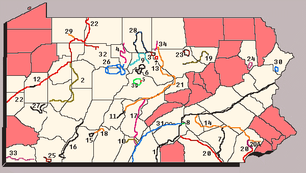
MAPS! This page lets you Click on a map and use the Compass and zoom bar to go anywhere in the U.S.A.!

There is also a trip maker. This lets you find out how to go anywhere in the U.S.A.! You can Zoom in so far (faster with the Zoom Bar) the map will be less than 1/2 a Mile wide.

Go To Maps!

Are You Picking Up the Trail side Litter ???

CONESTOGA   TRAIL SYSTEM:

The 63 mile trail developed, maintained and protected by the Lancaster Hiking Club.  Number 7 on above map.


Conestoga Trail click me

  Click Me

Help Maintain Trails.  It is Fun and rewarding!

HORSE-SHOE TRAIL: This trail is for hikers, horseback and pony riders.  The trail begins at Valley Forge and runs westward for about 135 miles to its junction with the Appalachian Trail on the crest of Sharp Mountain some twelve miles north of Hershey, PA.   See  #14 on the map above. Horse shoe Trail CLICK ME !

Click Me

Mid state Trial: is # 21 on above Map.

This is a 189 Mile Trail.


Mid State Trail CLCK  ON ME!

Click Me

Do Not Litter

"Tuscarora Trail": #31 on above map and the 

"Standing Stone Trail (Link Trail)": 

#17 on above map.  Standing Stone Trail (Link Trail)


Tuscarora and Link Trail CLICK ME PLEASE !

Click Me

Top of Page

Have you Maintained a Trail Lately ???

Holtwood & Lake Aldred
Trails and Attractions

Several maps and hiking trails near the York, PA. area!

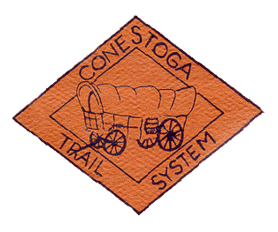
Holtwood Environmental Preserve offers hikers 39 miles of trails. The 15-mile Conestoga Trail, located on the east bank of the Susquehanna River, is a rugged pathway designed for experienced hikers. On the west bank, the Mason-Dixon Trail provides a beautiful but difficult day hike. Kelly's Run-Pinnacle Trail System consists of six miles of loop trails leading to a scenic vista that overlooks the Susquehanna River. Urey Overlook Trail leads to another spectacular vista. Lock 12 Historic Area. Otter Creek Campground MAP. And more!

Information about hiking trails and other points of interest at PP&L Inc.'s Holtwood and Lake Aldred nature and recreation areas. OTHER PP&L HIKING IN PA. LIST

PPL owned public parks CLICK ME

^CLICK ME!^

Details Page!

York County Parks pages done by York Hiking Club. 

Richard M. Nixon , John Rudy County Park , Rocky Ridge , William H. Kain , Apollo Park , Heritage Rail Trail , Spring Valley , Joseph Raab Park

York County Parks CLICK ME PLEASE!
    

   click me! 

Lancaster Nature Preserves CLICK ME PLEASE!

^ Click above image ^

Dots .......on the maps OUTLINE 

the areas land boundaries.

For these Preserves ONLY!

Holly Pointe Conservation Area , Upper Hopewell Forge Wildlife Sanctuary , Windolph Landing Nature Preserve , Chanastoka Nature Sanctuary , Turkey Hill Trail , Boyer Nature Preserve , Hauer-Trout Run Nature Preserve , Steinman Run Nature Preserve , Ray's Woods Nature Preserve , Greider's Run Nature Preserve , Tuquan Glen Nature Preserve , Wissler Run Nature Preserve , Fishing Creek Nature Preserve , Ferncliff Wildflower & Wildlife Preserve , Alexander - King Nature Preserve , Bell's Run Nature Preserve

Back up link to Nature Preserves - Lancaster PA

County of Lancaster, Pennsylvania

Parks & Recreation Department


25+ Years of Stewardship, Recreation & Conservation.


Photos: (2 of  the 7 parks.) 1 , 2

Parks' Events & Information

Local State Parks


State parks Click to Go there.

^ Click above word image ^

Codorus 

Gifford Pinchot

Kings Gap  

Nolde Forest

Rickets Glen

Little Buffalo State Park.


Full PA. Find a Park Map.


Find Maps of Parks.


Kings Gap Environmental Education Center Calendar of Events !


WEB CAMS

South of York County we have...

H

A

R

F

O

R

D

C

O

U

N

T

Y

P

A

R

K

S

I

T

E

S

GO

MARYLAND STATE PARKS

CLICK HERE

Maryland's Wildlife Management Areas

CLICK HERE 

(Click the numbers on the map)


ALSO BELOW

[Nature Tourism and Outdoor Adventures in Maryland]

^ Click Above image ^

MD. Main page index


Top of Page

Click Me Main Page Click Me News and Hike Dates Click Me Trails page top Click Me Photos page index Navigation sign


Webmaster: Jim T. yorkhikingclub@email.com

April 6, 2006

Have you had your pet Fixed ???


York County ParksRichard Nixon County Park , John Rudy County Park , Rocky Ridge County Park

William H. Kain County Park , Apollo County Park , Heritage Rail Trail York County Park ,

Spring Valley County Park

Tuscarora Trail , Mid state Trail , Horse-Shoe Trail, CONESTOGA   TRAIL